
 Yahoo Finance
 The weather conditions that may turn catastrophic fire fears into reality

The ongoing bushfire crisis affecting NSW looks set to reach unprecedented levels on Tuesday firefighters hoped would never come.
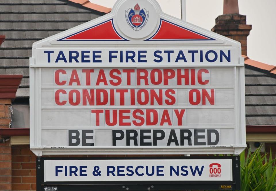
Greater Sydney, Greater Hunter and Illawarra-Shoalhaven areas have all been given a catastrophic fire danger rating – the highest possible level. It’s the first catastrophic warning given since a new system was introduced 10 years ago.
“It’s where people die” was the stark message from NSW Rural Fire Service Commissioner Shane Fitzsimmons on Monday, as he and his team prepared for the biggest day of their professional careers.
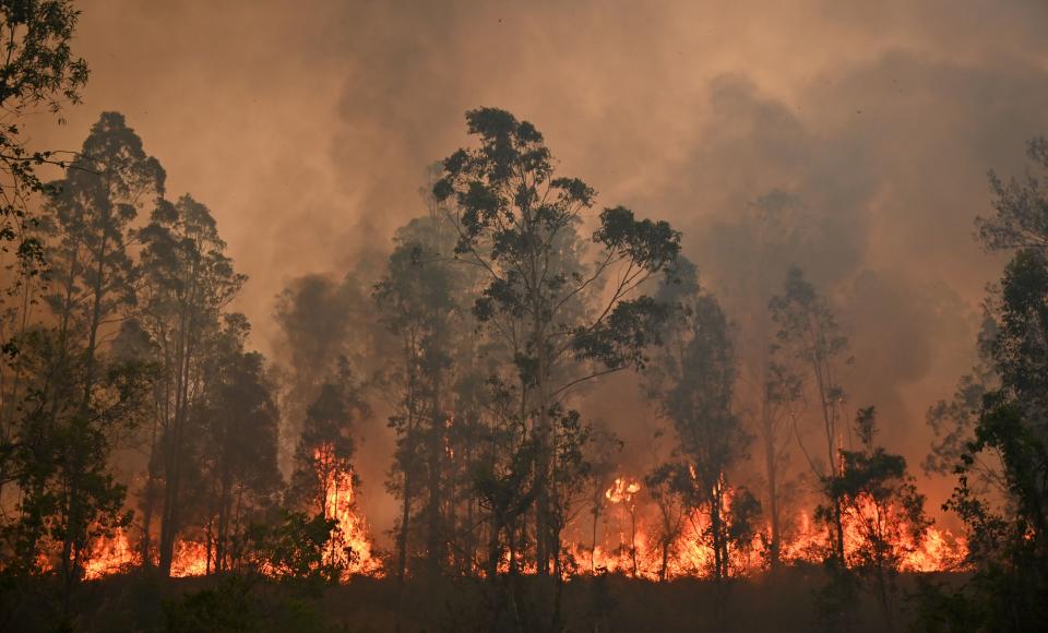
And while vast stretches of bone-dry bush caused by a prolonged and devastating period of drought for the state, it is extreme forecast conditions that proves to be the real danger facing the already exhausted Rural Fire Service.
The temperature on Tuesday across the state will surge to the high 30s, with many regions reaching 37 degrees.
Gloucester on the Mid North Coast will swelter to 38.
While those temperatures aren’t quite record-breaking, paired with strong north-westerly winds in excess of 90km/h, the ability for the existing bushfires to spread over large areas at an alarming rate is a devastating reality facing the crews on the ground.
According to the NSW RFS, with the winds predicted on Tuesday live embers will be able to travel 30km from an existing fire. It takes just one ember to start an entire new bushfire.
Tuesday's dry 'southerly buster' will cause any fires burning near the NSW coast to abruptly change direction. The latest ACCESS-C model has the change reaching Sydney around 7pm. pic.twitter.com/LdWfWhrM4g
— Ben Domensino (@Ben_Domensino) November 11, 2019
Embers from the devastating fires which ripped through the Mid North Coast region on Friday destroying 150 homes were only travelling up to 12km.
On Monday 35 local council areas declared a high-risk emergency, including densely populated regions such as Randwick, North Sydney and Parramatta.
And while residents in metropolitan regions have previously dismissed the ability of surrounding bushfires to obliterate suburban Sydney, bushfire behaviour expert Dr Trent Penman said it was now a reality.
He told the ABC the volatile wind conditions posed a real danger for large parts of the state capital due to the surrounding bushland in the north, west and south in close proximity.
"A single ember can start a fire in the bark mulch or straw mulch that someone has in their garden … which very quickly could move to the area around the house," he said.
Dry & gusty winds ahead of a trough & cold front will bring dangerous #fire weather conditions to fire-affected areas of #NSW & #Qld from tomorrow.
A change in wind direction can rapidly alter the course of fires & broaden fire fronts. Stay up to date at: https://t.co/d1Gl7t7n8p pic.twitter.com/6HS7FKhMDI— Bureau of Meteorology, Australia (@BOM_au) November 11, 2019
"I think it is important not to be complacent and to realise that the risk is not just in the forest but in surrounding areas as well."
Arriving cold front to wreak bushfire havoc
The Bureau of Meteorology said a predicted change in wind direction, from north to south late in the day, will only increase the area of bushland engulfed by fire.
As hot, dry air moves southeast across Australia on Tuesday, the fires are predicted to move and grow in the same direction.
But once a cold front arrives and heads northeast, the fire front will shift from relatively short to long thanks to the growth of the fire from the air mass.
Such a change happening mid afternoon will only hamper the relentless work of the 3000 firefighters deployed.
The front will bring a gusty southerly buster to the coastal fringe of the Illawarra, Sydney and Hunter districts in the late afternoon and evening, according to the Bureau of Meteorology.
RELATED: 'Absolute tragedy': Koala numbers decimated after bushfires destroy key habitats
The cold front is expected to sweep over Sydney about 7pm.
It will not subside until about 8am on Wednesday as it reaches the Queensland border.
“A combination of drying gusty winds and a shift in wind direction means people in the impacted areas will need to remain vigilant,” BoM meteorologist Grace Legge said.
Ms Legge said such unpredictable conditions posed a serious threat to residents and people needed to act early.
“This is an evolving and dangerous situation”.
Get out when you can
Mr Fitzsimmons said the predicted conditions on Tuesday is a situation the RFS hoped “would never come”.
He said it was vital residents acted quickly.
“Leaving early and well ahead of any fire in your area is the safest option,” he said.
“Safest options might include going to the local shopping centre, going into town, where you're not in the bushfire-prone area."
Mr Fitzsimmons said fires could spread so quickly in such conditions people found themselves in severe danger before help arrived.
"There are simply not enough fire trucks for every house. If you call for help, you may not get it,” the RFS said in a statement.
RELATED: The hundreds of schools closed due to bushfires
“Do not expect a knock on the door. Do not expect a phone call. Your safest option will always be to leave early.”
Firefighters attempted tactical backburning operations on Monday night but Mr Fitzsimmons said their impact would be "tenuous at best".
Emergency Services Minister David Elliott said residents were facing what "could be the most dangerous bushfire week this nation has ever seen".
With AAP
Do you have a story tip? Email: newsroomau@yahoonews.com.
You can also follow us on Facebook and Twitter, download the Yahoo News app from the App Store or Google Play and stay up to date with the latest news with Yahoo’s daily newsletter. Sign up here.
