
 Yahoo Finance
 Toubani Successfully Extends Overall Kobada Mineralisation by 1 km

Figure 1

Figure 2
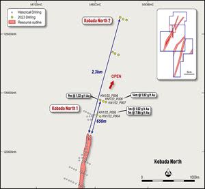
Figure 3

Figure 4

TORONTO, March 07, 2023 (GLOBE NEWSWIRE) -- Toubani Resources, Inc (ASX: TRE; TSX-V: TRE) (“Toubani Resources” or the “Company”) is pleased to provide the first set of results from the ongoing drilling program at its Kobada Gold Project in southern Mali.
Highlights
Drilling has extended mineralisation by almost 1km to the north and south of the Kobada Main Deposit
Kobada Main Deposit currently hosts a Mineral Resource1 of 3.1 million ounces of gold over a strike length of 4.5km
Mineralisation remains open north and south of the Kobada Main Deposit
Excellent first results from the Kobada North 1 target area with 9m at 1.32g/t and 14m at 1.02g/t
Further assay results at Kobada North 2 testing along an additional 1.7km of strike are pending
Drilling continues on site with the focus now moving to step out holes at the Gosso target, where previous drilling has already intersected mineralisation
Chief Executive Officer, Phil Russo commented: “For the first drill holes of the program to extend mineralisation by 1 km, including 650 meters at Kobada North alone, is an exceptional result. These results demonstrate both the scale and the potential of the Kobada district and to be able to expand the footprint of mineralisation so quickly, while still open along strike, is a significant step forward in unlocking this project. We believe we have a very large system across an extensive and, remarkably, still underexplored belt. We now look forward to drilling at Gosso, which is currently underway and has returned excellent initial results in historical drilling.”
Drilling Results and Commentary
Drilling was designed to test potential extensions to mineralisation at the Kobada Main Deposit (Figure 1). Extensive artisanal workings can be found along strike and along trend from Kobada Main, yet almost no drilling has been undertaken.
_____________
1 Combined Measured, Indicated and Inferred Mineral Resource of 103.57Mt at 0.94g/t.
Refer to the Company's prospectus dated 12 September 2022 and released on ASX on 25 November 2022
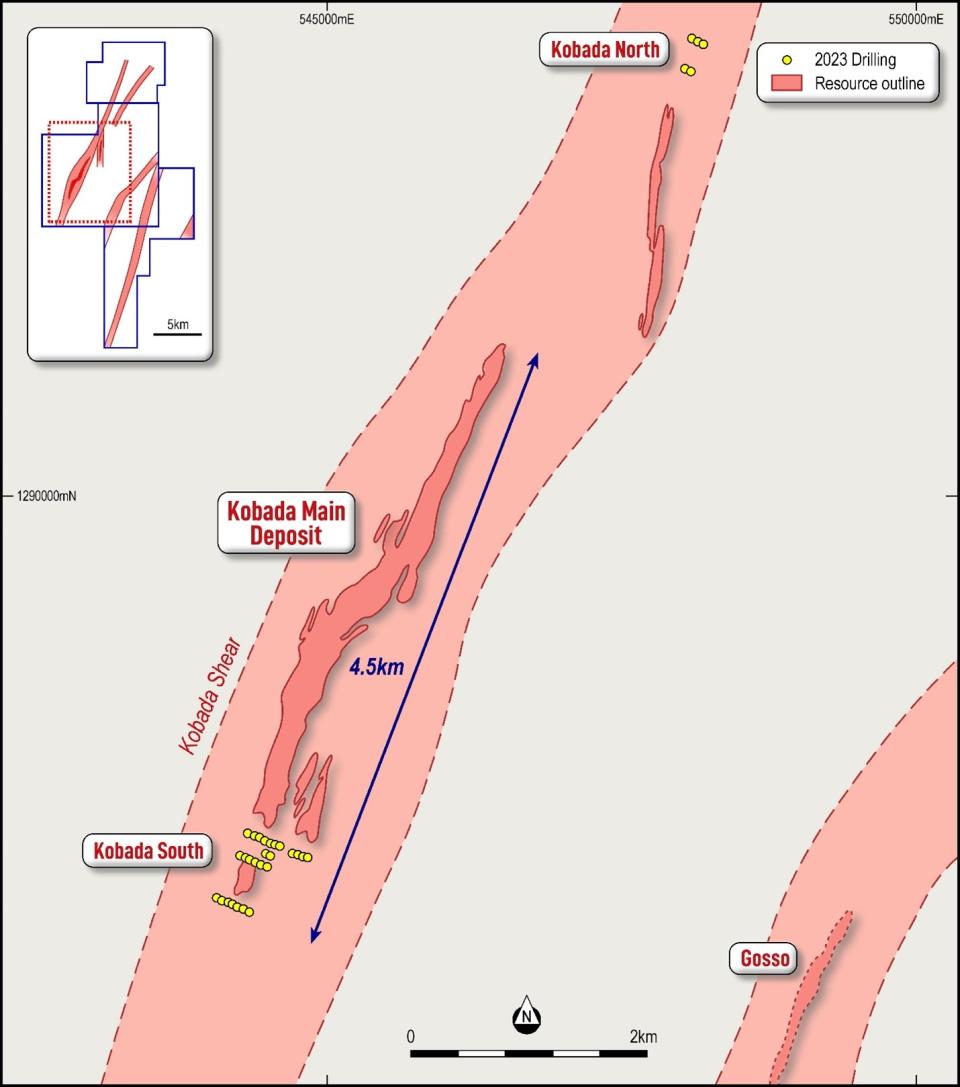
Figure 1: Plan showing location of Kobada North and Kobada South
At Kobada North 1, two fences of drilling were completed stepping out 400 metres and 650 metres, respectively, north of the last fence of drilling within the Kobada Main resource. The drilling tested below and adjacent to artisanal workings.
Results are shown on Figure 2 and 3 and detailed in Appendix 1 with key intersections including:
9m at 1.32g/t from 112 metres including 4m at 2.64g/t (KN1/22_P009)
14m at 1.02g/t from 81 metres including 1m at 2.28g/t and 1m at 3.75g/t (KN1/22_P008)
1m at 7.86g/t from 59 metres (KN1/22_P007)
With drilling successfully confirming the continuity of the mineralised system to the north, follow up drilling will now be planned to systematically test the tenor of mineralisation along the structure. This will then enable this area to be included in a forthcoming update to the Kobada Mineral Resource.

Figure 2: Plan showing Kobada North targets and Toubani drilling
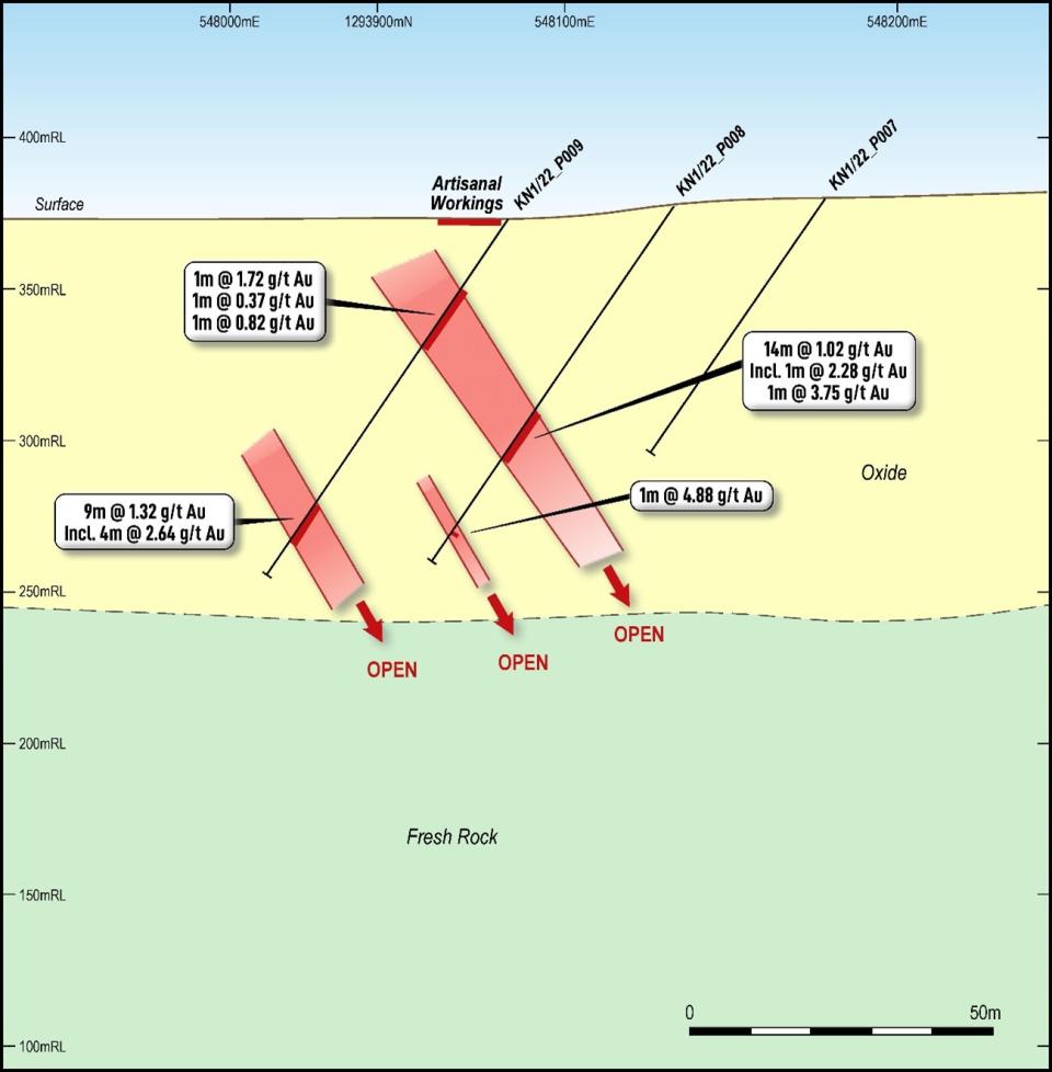
Figure 3: Kobada North 1 cross-section showing results from Toubani drilling
At Kobada South, three fences of drilling were completed. The most southerly of these stepped out 250 metres south from the last fence of drilling within the Kobada Main resource and successfully intersected mineralisation, including:
3m at 1.81g/t from 50m and 3m at 1.20g/t from 61m (KS22_P003).
Drilling was also carried out to infill a 500m gap in drilling at the southern end of the Mineral Resource with results to inform a resource update planned for later in 2023. Key results included:
1m at 8.35g/t from 68m (KS22_P012) and 3m at 1.8g/t from 82m (KS22_P014).
In addition, drilling was completed to test extensions to mineralisation on a parallel lode to the Kobada Main lode. Intersections of 2m at 0.75g/t from 6m and 4m at 0.52g/t from 40m (KS22_P025) were returned, demonstrating continuity of mineralisation on this eastern lode for a further 200m. Further work is planned in future programs to test the potential of this parallel lode.
All results are shown on Figure 4 and detailed in Appendix 1.

Figure 4: Kobada South showing Toubani drilling location and results
Forward Work Program
Following the drilling at Kobada North 1 the drilling rig has completed two further fences of drilling at Kobada North 2, which steps out a further 1.7 km along strike to the north to test for the presence of the mineralised system. The fences are sited based on interpretation of geophysical data and artisanal workings. Results are awaited with laboratory turn around times significantly improved in recent weeks.
The rig is currently drilling at the Gosso target, which is located on a parallel structure to the Kobada Main Deposit. Previous drilling at Gosso2 returned results including:
36m at 1.64 g/t from 72m (KBRC11-140)
3.1m at 4.25 g/t from 34.6m (G20_PH3A_20)
3m at 2.59 g/t from 30m (KBRC11-144)
5m at 1.90 g/t from 133m (KBRC11-142)
This announcement has been authorised for release by the Board.
For more information:
Phil Russo | Jane Morgan |
Chief Executive Officer and Executive Director | Investor and Media Relations |
+(61) 478 138 627 | + 61 (0) 405 555 618 |
About Toubani Resources Inc
Toubani Resources (ASX: TRE; TSX-V: TRE) is an exploration and development Company with a focus on building Africa’s next mid-tier gold producer. The Company has a highly experienced Board and management team with a proven African track record in advancing projects through exploration, development and into production.
For more information regarding Toubani Resources visit our website at www.toubaniresources.com
_____________
2 Refer to the Company's prospectus dated 12 September 2022 and released on ASX on 25 November 2022
Competent Person’s Statement
The information in this press release relating to geology and Exploration Results is based on information compiled, reviewed and assessed by Mr. Bill Oliver, who is a Member of the Australasian Institute of Mining and Metallurgy and the Australian Institute of Geoscientists. Mr. Oliver is a consultant to the Company and has sufficient experience which is relevant to the style of mineralisation and type of deposit under consideration and to the activity which he is undertaking to qualify as a Competent Person as defined by the 2012 Edition of the Australasian Code for reporting of Exploration Results, Mineral Resources and Ore Reserves (JORC Code). Mr. Oliver consents to the inclusion of the information in the form and context in which it appears.
The information in this press release relating to the Mineral Resources at the Kobada Deposit is extracted from Company's prospectus dated 12 September 2022 and released on ASX on 25 November 2022 (Prospectus) which is available on the ASX announcements platform. The Company confirms that it is not aware of any new information or data that materially affects the information relating to the Mineral Resources at the Kobada Deposit included in the Prospectus and all material assumptions and technical parameters underpinning the Mineral Resources estimate in the Prospectus continue to apply and have not materially changed.
Cautionary statements
This press release contains “forward-looking information” within the meaning of applicable Canadian securities legislation. Forward-looking information includes, but is not limited to, statements regarding the listing on the Australian Securities Exchange, the expansion of mineral resources and reserves, and drilling and exploration plans of the Company. Generally, forward-looking information can be identified by the use of forward-looking terminology such as “plans”, “expects” or “does not expect”, “is expected”, “budget”, “scheduled”, “estimates”, “forecasts”, “intends”, “anticipates” or “does not anticipate”, or “believes”, or variations of such words and phrases or statements that certain actions, events or results “may”, “could”, “would”, “might” or “will be taken”, “occur” or “be achieved”. Forward-looking information is subject to known and unknown risks, uncertainties and other factors that may cause the actual results, level of activity, performance or achievements of the Company to be materially different from those expressed or implied by such forward-looking information, including but not limited to: receipt of necessary approvals from Canadian and Australian regulatory authorities; general business, economic, competitive, political and social uncertainties; future prices of mineral prices; accidents, labour disputes and shortages; available infrastructure and supplies; the COVID-19 pandemic and other risks of the mining industry. Although the Company has attempted to identify important factors that could cause actual results to differ materially from those contained in forward-looking information, there may be other factors that cause results not to be as anticipated, estimated or intended. There can be no assurance that such information will prove to be accurate, as actual results and future events could differ materially from those anticipated in such statements. Accordingly, readers should not place undue reliance on forward-looking information. The Company does not undertake to update any forward-looking information, except in accordance with applicable securities laws.
NEITHER TSX VENTURE EXCHANGE NOR ITS REGULATION SERVICES PROVIDER (AS THAT TERM IS DEFINED IN THE POLICIES OF THE TSX VENTURE EXCHANGE) ACCEPTS RESPONSIBILITY FOR THE ADEQUACY OR ACCURACY OF THIS RELEASE
Appendix 1. Kobada RC Drilling Data and Results
Hole ID | Target | Easting | Northing | RL | Dip | Azi | Depth | From | To | Length | Au (g/t) |
KN1/22_P004 | Kobada North 1 | 548080 | 1293602 | 382 | 55 | 295 | 140 | 117 | 119 | 2 | 0.30 |
|
|
|
|
|
|
|
| 120 | 122 | 2 | 0.34 |
|
|
|
|
|
|
|
| 135 | 138 | 3 | 0.72 |
KN1/22_P005 | Kobada North 1 | 548029 | 1293625 | 375 | 55 | 295 | 140 | 31 | 32 | 1 | 1.52 |
|
|
|
|
|
|
|
| 59 | 60 | 1 | 7.86 |
KN1/22_P007 | Kobada North 1 | 548179 | 1293841 | 380 | 55 | 295 | 102 |
| NSI |
|
|
KN1/22_P008 | Kobada North 1 | 548131 | 1293857 | 377 | 55 | 295 | 140 | 81 | 95 | 14 | 1.02 |
|
|
|
|
|
|
| incl. | 81 | 82 | 1 | 2.28 |
|
|
|
|
|
|
| incl. | 85 | 86 | 1 | 3.75 |
|
|
|
|
|
|
|
| 107 | 111 | 4 | 0.50 |
|
|
|
|
|
|
|
| 129 | 130 | 1 | 4.88 |
|
|
|
|
|
|
|
| 135 | 136 | 1 | 0.86 |
KN1/22_P009 | Kobada North 1 | 548083 | 1293883 | 372 | 55 | 295 | 140 | 27 | 28 | 1 | 1.72 |
|
|
|
|
|
|
|
| 43 | 44 | 1 | 0.86 |
|
|
|
|
|
|
|
| 112 | 121 | 9 | 1.32 |
|
|
|
|
|
|
| incl. | 112 | 116 | 4 | 2.64 |
|
|
|
|
|
|
|
| 126 | 127 | 1 | 0.86 |
KS22_P001 | Kobada South | 544332 | 1286489 | 391 | 55 | 295 | 150.00 |
| NSI |
|
|
KS22_P002 | Kobada South | 544285 | 1286507 | 397 | 55 | 295 | 72.00 | 63 | 67 | 4 | 0.66 |
KS22_P003 | Kobada South | 544241 | 1286526 | 389 | 55 | 295 | 140.00 | 36 | 41 | 5 | 0.61 |
|
|
|
|
|
|
|
| 50 | 53 | 3 | 1.81 |
|
|
|
|
|
|
|
| 61 | 64 | 3 | 1.2 |
KS22_P004 | Kobada South | 544191 | 1286550 | 367 | 55 | 295 | 150.00 | 121 | 123 | 2 | 0.29 |
KS22_P005 | Kobada South | 544152 | 1286559 | 389 | 55 | 295 | 150.00 |
| NSI |
|
|
KS22_P006 | Kobada South | 544107 | 1286577 | 389 | 55 | 295 | 150.00 |
| NSI |
|
|
KS22_P007 | Kobada South | 544054 | 1286604 | 391 | 55 | 295 | 150.00 | 17 | 18 | 1 | 0.69 |
KS22_P012 | Kobada South | 544484 | 1286859 | 385 | 55 | 295 | 124.00 | 0 | 2 | 2 | 0.31 |
|
|
|
|
|
|
|
| 11 | 13 | 2 | 0.53 |
|
|
|
|
|
|
|
| 21 | 27 | 6 | 0.28 |
|
|
|
|
|
|
|
| 42 | 48 | 6 | 0.27 |
|
|
|
|
|
|
|
| 52 | 56 | 4 | 0.31 |
|
|
|
|
|
|
|
| 68 | 69 | 1 | 8.35 |
|
|
|
|
|
|
|
| 74 | 75 | 1 | 1.65 |
|
|
|
|
|
|
|
| 120 | 124 | 4 | 0.5 |
KS22_P013 | Kobada South | 544434 | 1286877 | 403 | 55 | 295 | 150.00 | 119 | 120 | 1 | 0.38 |
|
|
|
|
|
|
|
| 129 | 130 | 1 | 0.45 |
|
|
|
|
|
|
|
| 149 | 150 | 1 | 1.87 |
KS22_P014 | Kobada South | 544390 | 1286900 | 401 | 55 | 295 | 127.00 | 15 | 16 | 1 | 1.96 |
|
|
|
|
|
|
|
| 82 | 85 | 3 | 1.8 |
|
|
|
|
|
|
| incl | 82 | 83 | 1 | 4.94 |
|
|
|
|
|
|
|
| 102 | 103 | 1 | 0.67 |
KS22_P015 | Kobada South | 544335 | 1286920 | 404 | 55 | 295 | 140.00 | 11 | 16 | 5 | 0.28 |
|
|
|
|
|
|
|
| 56 | 57 | 1 | 1.34 |
KS22_P016 | Kobada South | 544296 | 1286936 | 407 | 55 | 295 | 150.00 |
| NSI |
|
|
KS22_P017 | Kobada South | 544250 | 1286953 | 413 | 55 | 295 | 150.00 |
| NSI |
|
|
KS22_P018 | Kobada South | 544517 | 1286953 | 422 | 55 | 295 | 150.00 | 72 | 74 | 2 | 0.27 |
|
|
|
|
|
|
|
| 79 | 80 | 1 | 0.32 |
KS22_P019 | Kobada South | 544475 | 1286971 | 402 | 55 | 295 | 150.00 | 84 | 85 | 1 | 0.35 |
|
|
|
|
|
|
|
| 111 | 113 | 2 | 0.59 |
|
|
|
|
|
|
|
| 146 | 148 | 2 | 0.32 |
KS22_P024 | Kobada South | 544825 | 1286935 | 433 | 55 | 295 | 100.00 | 39 | 41 | 2 | 0.74 |
|
|
|
|
|
|
|
| 66 | 68 | 2 | 0.71 |
KS22_P025 | Kobada South | 544780 | 1286950 | 430 | 55 | 295 | 100.00 | 6 | 8 | 2 | 0.75 |
|
|
|
|
|
|
|
| 40 | 44 | 4 | 0.52 |
KS22_P026 | Kobada South | 544738 | 1286971 | 412 | 55 | 295 | 100.00 | 15 | 16 | 1 | 0.32 |
KS22_P027 | Kobada South | 544699 | 1286988 | 423 | 55 | 295 | 100.00 | 17 | 18 | 1 | 0.45 |
|
|
|
|
|
|
|
| 58 | 59 | 1 | 0.46 |
KS22_P029 | Kobada South | 544599 | 1287029 | 417 | 55 | 295 | 100.00 | 66 | 67 | 1 | 4.29 |
|
|
|
|
|
|
|
| 94 | 95 | 1 | 0.48 |
KS22_P030 | Kobada South | 544558 | 1287046 | 425 | 55 | 295 | 100.00 | 88 | 89 | 1 | 0.58 |
|
|
|
|
|
|
|
| 96 | 99 | 3 | 0.41 |
KS22_P031 | Kobada South | 544513 | 1287064 | 430 | 55 | 295 | 100.00 | 89 | 90 | 1 | 0.58 |
|
|
|
|
|
|
|
| 96 | 99 | 3 | 0.41 |
KS22_P032 | Kobada South | 544463 | 1287084 | 430 | 55 | 295 | 100.00 | 25 | 26 | 1 | 1.72 |
KS22_P033 | Kobada South | 544415 | 1287106 | 422 | 55 | 295 | 100.00 | 13 | 15 | 2 | 0.39 |
KS22_P034 | Kobada South | 544369 | 1287122 | 419 | 55 | 295 | 100.00 |
| NSI |
|
|
KS22_P035 | Kobada South | 544322 | 1287140 | 419 | 55 | 295 | 100.00 | 25 | 26 | 1 | 0.39 |
Appendix 2. The following tables are provided to ensure compliance with JORC Code requirements for the reporting of Exploration Results from the Kobada Project
Section 1 Sampling Techniques and Data
(Criteria in this section apply to all succeeding sections.)
Criteria | JORC Code explanation | Commentary |
Sampling techniques |
| Drilling samples collected using reverse circulation (RC) percussion drilling. |
Drilling techniques |
| Reverse Circulation drilling using 127mm face sampling hammer |
Drill sample recovery |
| RC samples are weighed to quantify recovery |
Logging |
| Geological logging of RC drilling is completed to an acceptable standard for use in Mineral Resource estimation. |
Sub-sampling techniques and sample preparation |
| All RC samples are split using a riffle splitter with one split (approximately 1 to 2 kg) collected for laboratory testing and the remaining amount after splitting is retained in the bulk bag for future reference. All samples were sampled dry. |
Quality of assay data and laboratory tests |
| Samples were submitted to the SANAS and ISO/IEC 17025 accredited SGS Laboratory in Bamako. Samples were tested by fire assay with an AAS finish. Samples < 3.0 kg were dried in trays, crushed to a nominal 2 mm using a jaw crusher, and then < 1.5 kg were split using a Jones-type riffle splitter. Reject sample was retained in the original bag and stored. The sample was pulverised in an LM2 pulveriser to a nominal 85 % passing 75 µm. An approximately 200 g subsample was taken for assay, with the pulverised residue retained in a plastic bag. All the preparation equipment was flushed with barren material prior to the commencement of the job. A 50 g subsample was fused with a litharge-based flux, cupelled, and the prill is dissolved in aqua regia, and gold is determined by flame AAS (Detection Limit 0.01 ppm). |
Verification of sampling and assaying |
| Significant intersections have been estimated by consultants to the company and cross checked. |
Location of data points |
| The drillhole collars have been located with a Garmin handheld GPS with a ± 5 m accuracy |
Data spacing and distribution |
| Drillholes are being drilled at spacings between 50 and 100m on section, with sections 200 – 400 metres apart. |
Orientation of data in relation to geological structure |
| Drilling orientation is planned perpendicular to the regional structural trend (NNE). |
Sample security | The measures taken to ensure sample security. | Industry best practice has been applied to the drilling sampling processes carried out. Drilled samples were transported in a manner to prevent loss or cross-contamination. All samples were stored in a secure storage facility pending dispatch to laboratory in Bamako. In line with protocol, two people were used to transport the samples directly to the laboratory. Once at the laboratory, the samples were subject to the standard security measures of the laboratory. |
Audits or reviews |
| No audits have been completed. |
Section 2 Reporting of Exploration Results
(Criteria in this section apply to all succeeding sections.)
Criteria | JORC Code explanation | Commentary |
Mineral tenement and land tenure status |
| African Gold Group Mali SARL, a wholly-owned subsidiary of TRE, holds a mining permit No. PE 15/22 encompassing an area of 135.7 km² for the Kobada project area valid to 30 July 2045. Two adjacent exploration permits are also held, namely Kobada-Est (No. PR 18/957 over 77 km² valid to 15 August 2024 for three years) and Faraba (for which renewal was granted under Arrêté No. 2021-3226/MMP-SG effective 6 April 2021 for a further three years. |
Exploration done by other parties |
| Bureau de Recherches Géologiques et Minières conducted historical exploration in 1982 to 1988, which respectively identified and delineated the Kobada Shear Zone through geochemistry surveys and latter diamond drilling. La Source undertook RC drilling in 1996, followed in 2002 and 2004 respectively by RC and air core drilling by Cominor. IAMGold completed diamond and RC drilling in 2009. |
Geology |
|
|
Drill hole Information |
| Refer Appendix 1 |
Data aggregation methods |
| Averaging is weighted based on length, with all samples 1m in downhole length. |
Relationship between mineralisation widths and intercept lengths |
| Downhole lengths are presented in Appendix 1. True widths have not been calculated. |
Diagrams |
| • Refer to figures within this report. |
Balanced reporting |
| All meaningful information has been included in the body of the text and all results are presented in Appendix 1. |
Other substantive exploration data |
| All material data and information is detailed in the Company's prospectus dated 12 September 2022 and released on ASX on 25 November 2022. |
Further work |
| As detailed in the text – drilling is ongoing at the project and further drilling will be planned to follow up these results. |
Photos accompanying this announcement are available at
https://www.globenewswire.com/NewsRoom/AttachmentNg/ca04066b-86f1-4a93-a341-db2ce2fbd114
https://www.globenewswire.com/NewsRoom/AttachmentNg/e79faaa2-40c7-4dfc-b6ab-3ea1a9b9c109
https://www.globenewswire.com/NewsRoom/AttachmentNg/8aa4e810-72ef-49db-addc-5e422fb15e0a
https://www.globenewswire.com/NewsRoom/AttachmentNg/2f7840a0-8977-44d8-b6d0-1c16e341f5de

