
 Yahoo Finance
 Toubani Continues to Increase Strike of Mineralisation at Kobada

Figure 1

Figure 2

Figure 3
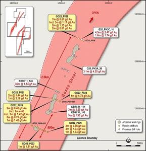
Figure 4

TORONTO, April 10, 2023 (GLOBE NEWSWIRE) -- Toubani Resources, Inc (ASX: TRE; TSX-V: TRE) (“Toubani Resources” or the “Company”) is pleased to provide further results from the ongoing drilling program at its 3.1Moz Kobada Gold Project in southern Mali. The Mineral Resources1 occur over a strike length of 4.5km.
Highlights
Drilling at Kobada North has confirmed continuity and further extended mineralisation north of the Kobada Main Deposit with mineralisation now intersected over 2km from previous drilling, and remains open
Shallow, oxide mineralisation intersected in drilling at the Gosso target with results of 1m at 5.78g/t, 2m at 1.44g/t, 1m at 3.16g/t, 3m at 1.34g/t, 3m at 1.17g/t, and 2m at 1.15g/t
Mineralisation at Gosso remains open to the north and south with Toubani’s drilling increasing the strike of known mineralisation to over 2km
All targets tested in the current program to date have intersected mineralisation
RC drilling continues on site with drilling recently completed at the Kobada Est target, where high grade auger results were received in late 2022
Drilling now in progress at Kobada West, a previously undrilled structure parallel to the Kobada Main Shear with results anticipated shortly
Following the success of this current campaign, Toubani has increased its drilling program by 3,000m to a total of 13,750m
Chief Executive Officer, Phil Russo commented: “The goal of our current program is to drill test several high value targets outside the 3.1Moz Kobada Main deposit. Following the success of our initial results last month, we are pleased to have continued to intersect mineralisation and extend strike at all targets tested so far. Our belief is that the potential scale of Kobada is much more extensive, and our drilling program continues to confirm this. Given the success of our campaign, we have elected to increase the program by an additional 3,000m with the overall program set to be completed in the coming weeks and assays due thereafter.”
Drilling Results and Commentary
At Kobada North 2, two fences of drilling were completed stepping out 1,500 metres and 2,100 metres, respectively, north of the last fence of drilling within the Kobada Main resource. The drilling tested below and adjacent to artisanal workings.
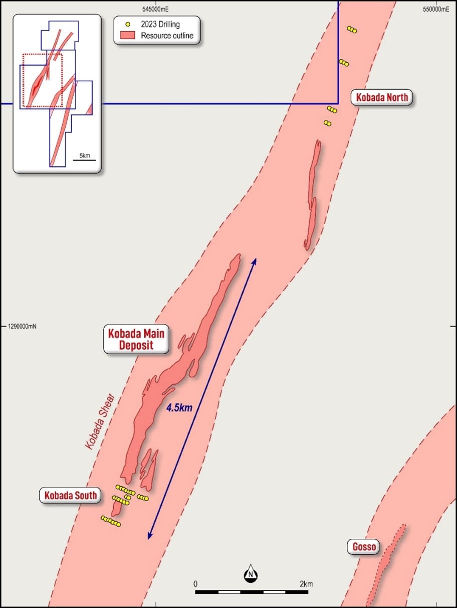
Figure 1: Plan showing location of Kobada North and Kobada South
Drilling was designed to test potential extensions to mineralisation at the Kobada Main Deposit (Figure 1). Extensive artisanal workings can be found along strike and along trend from Kobada Main, yet almost no drilling has been undertaken.
Drilling successfully confirmed the continuation of the system as shown on Figure 2 with intersections of:
1m at 8.51g/t from 48 metres (KN2/22_P003 = 1,500m north of Kobada, refer Appendix 1)
1m at 0.64g/t from 137 metres (KN1/22_P010 = 2,100m north of Kobada, refer Appendix 1)
Inspection of drill chips and field mapping indicates that shearing is less intense in the area of the Kobada North 2 target vs the Kobada North 1 target, where results of 9m at 1.32g/t and 14m at 1.02g/t were intersected in recent drilling2. Results confirm the mineralisation model of regional scale shear zones providing the first order control on mineralisation with localised cross-cutting structures providing the second order control and, importantly, controlling the higher grade mineralisation.
Kobada North 2 is located 900m north of the drilling at Kobada North 1 and these results lead to two follow up workflows:
Immediate follow up in the Kobada North 1 area to delineate newly identified mineralisation
Follow up for Kobada North 2 utilising systematic regional scale exploration tools such as auger or aircore drilling to map the continuation of the Kobada Main shear and explore for higher strain areas which will be the “hotspots” for higher grade gold mineralisation

Figure 2: Plan showing Kobada North targets and Toubani drilling
At Gosso, drilling aimed to test the northern and southern extents of the deposit as well as a line of drilling through the centre of the target. Mineralisation at Gosso is hosted on a parallel structure to the Kobada Main Deposit, which has had relatively little drill testing compared to the Kobada Shear.
Previous drilling at Gosso3 returned results including:
36m at 1.64 g/t from 72m (KBRC11-140)
3.1m at 4.25 g/t from 34.6m (G20_PH3A_20)
3m at 2.59 g/t from 30m (KBRC11-144)
5m at 1.90 g/t from 133m (KBRC11-142)
Toubani’s drilling has successfully extended the known strike of mineralisation at Gosso from 1,600m to 2,100m as well as confirming mineralisation is open to the north and south of the target.
Results have confirmed the shallow, oxide nature of mineralisation with several higher grade zones intersected. Mineralisation is clearly hosted in a similar structural setting to that outlined for the Kobada Shear above, with multiple intersections on each section likely indicative of a strong influence of cross-cutting E-W structures. Detailed interpretation of these results is in progress to aid future targeting.
All results from Gosso are shown on Figure 3 and tabulated in Appendix 1 with intersections including:
1m at 5.78g/t from 134 metres (GO22_P024 = central line)
9m at 0.42g/t from 8 metres (includes 2m void from artisanal mining, GO22_P026 = central line)
2m at 1.44g/t from 49 metres and 1m at 3.16g/t from 80 metres (GO22_P027 = central line)
3m at 1.34g/t from 32 metres and 2m at 0.98g/t from 25 metres (GO22_P029 = central line)
1m at 1.81g/t from 110 metres (GO22_P032 = southern line)
7m at 0.67g/t from 15 metres, including 3m at 1.17g/t from 19 metres, and 2m at 1.15g/t from 45 metres (GO22_P039 = northern line)
Results from GO22_P039 are significant as this hole was drilled on section with G20_PH3C_16, previously the northernmost hole at Gosso. To successfully intersect multiple lodes of mineralisation is encouraging and warrants further drilling to the north of the prospect.
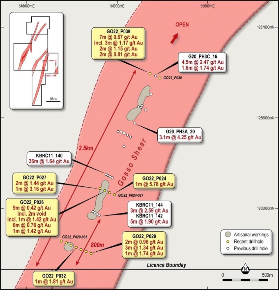
Figure 3: Gosso showing Toubani drilling location and results
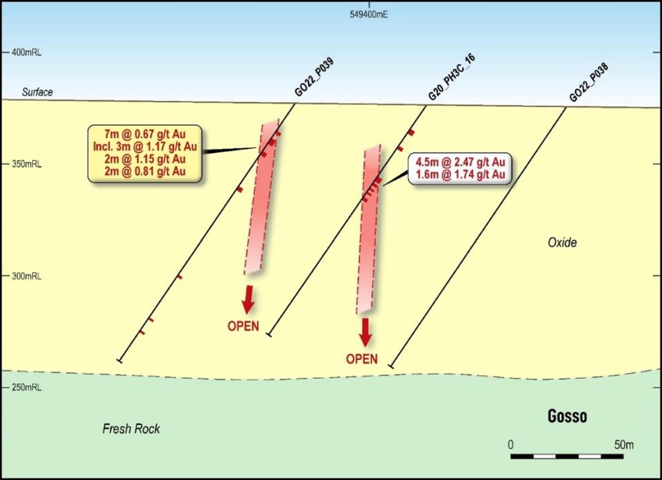
Figure 4: Gosso cross-section showing results from Toubani drilling
Forward Work Program
Drilling continues on site with drilling recently completed at the Kobada Est target, where high grade auger results were received in 20224 including:
20.69 g/t Au over 8.0 m from 2.0 m to 10.0 m (Drill hole E-423)
including 78.9 g/t Au over 2.0 m
including 3.14 g/t Au over 2.0 m
1.81 g/t Au over 8.0 m from 10.0 m to 18.0 m (Drill hole E-412)
including 3.94 g/t Au over 2.0 m
2.42 g/t Au over 2.0 m from 0.0 m to 2.0 m (Drill hole E-417)
The Company is awaiting results from the SGS laboratory in Bamako.
Drilling is currently in progress at Kobada West, a previously undrilled structure parallel to Kobada Main which hosts substantial artisanal workings.
Given the success of the program in extending mineralisation at Koboda North and Gosso, as well as identification of further high value targets, the Company has increased its current program by 3,000m to 13,750m.
Drilling is focused on following up targets identified by recently completed drilling at Kobada North, from artisanal workings at Kobada West and the interpreted junction between the Kobada and Foroko shears. Significant artisanal workings are evident at the latter targets yet little to no previous drill testing has occurred.
This announcement has been authorised for release by the Board.
For more information:
Phil Russo | Jane Morgan |
Chief Executive Officer and Executive Director | Investor and Media Relations |
+(61) 478 138 627 | + 61 (0) 405 555 618 |
|
|
About Toubani Resources Inc
Toubani Resources (ASX: TRE; TSX-V: TRE) is an exploration and development Company with a focus on building Africa’s next mid-tier gold producer with its advanced Kobada Gold Project. The Company has a highly experienced Board and management team with a proven African track record in advancing projects through exploration, development and into production.
For more information regarding Toubani Resources visit our website at www.toubaniresources.com.
Competent Person’s Statement
The information in this press release relating to geology and Exploration Results is based on information compiled, reviewed and assessed by Mr. Bill Oliver, who is a Member of the Australasian Institute of Mining and Metallurgy and the Australian Institute of Geoscientists. Mr. Oliver is a consultant to the Company and has sufficient experience which is relevant to the style of mineralisation and type of deposit under consideration and to the activity which he is undertaking to qualify as a Competent Person as defined by the 2012 Edition of the Australasian Code for reporting of Exploration Results, Mineral Resources and Ore Reserves (JORC Code). Mr. Oliver consents to the inclusion of the information in the form and context in which it appears.
The information in this press release relating to the Mineral Resources at the Kobada Deposit is extracted from Company's prospectus dated 12 September 2022 and released on ASX on 25 November 2022 (Prospectus) which is available on the ASX announcements platform. The Company confirms that it is not aware of any new information or data that materially affects the information relating to the Mineral Resources at the Kobada Deposit included in the Prospectus and all material assumptions and technical parameters underpinning the Mineral Resources estimate in the Prospectus continue to apply and have not materially changed.
Cautionary statements
This press release contains “forward-looking information” within the meaning of applicable Canadian securities legislation. Forward-looking information includes, but is not limited to, statements regarding the listing on the Australian Securities Exchange, the expansion of mineral resources and reserves, and drilling and exploration plans of the Company. Generally, forward-looking information can be identified by the use of forward-looking terminology such as “plans”, “expects” or “does not expect”, “is expected”, “budget”, “scheduled”, “estimates”, “forecasts”, “intends”, “anticipates” or “does not anticipate”, or “believes”, or variations of such words and phrases or statements that certain actions, events or results “may”, “could”, “would”, “might” or “will be taken”, “occur” or “be achieved”. Forward-looking information is subject to known and unknown risks, uncertainties and other factors that may cause the actual results, level of activity, performance or achievements of the Company to be materially different from those expressed or implied by such forward-looking information, including but not limited to: receipt of necessary approvals from Canadian and Australian regulatory authorities; general business, economic, competitive, political and social uncertainties; future prices of mineral prices; accidents, labour disputes and shortages; available infrastructure and supplies; the COVID-19 pandemic and other risks of the mining industry. Although the Company has attempted to identify important factors that could cause actual results to differ materially from those contained in forward-looking information, there may be other factors that cause results not to be as anticipated, estimated or intended. There can be no assurance that such information will prove to be accurate, as actual results and future events could differ materially from those anticipated in such statements. Accordingly, readers should not place undue reliance on forward-looking information. The Company does not undertake to update any forward-looking information, except in accordance with applicable securities laws.
NEITHER TSX VENTURE EXCHANGE NOR ITS REGULATION SERVICES PROVIDER (AS THAT TERM IS DEFINED IN THE POLICIES OF THE TSX VENTURE EXCHANGE) ACCEPTS RESPONSIBILITY FOR THE ADEQUACY OR ACCURACY OF THIS RELEASE
Appendix 1. Kobada RC Drilling Data and Results
Hole ID | Target | Easting | Northing | RL | Dip | Azi | Depth | From | To | Length | Au (g/t) |
KN2/22_P001 | Kobada North 1 | 548387 | 1294653 | 380 | 55 | 295 | 140 |
| NSI |
|
|
KN2/22_P002 | Kobada North 1 | 548332 | 1294672 | 382 | 55 | 295 | 140 |
| NSI |
|
|
KN2/22_P003 | Kobada North 1 | 548289 | 1294696 | 388 | 55 | 295 | 140 | 28 | 29 | 1 | 0.3 |
|
|
|
|
|
|
|
| 48 | 49 | 1 | 8.51 |
KN2/22_P008 | Kobada North 1 | 548527 | 1295240 | 396 | 55 | 295 | 140 |
| NSI |
|
|
KN2/22_P009 | Kobada North 1 | 548473 | 1295257 | 396 | 55 | 295 | 140 |
| NSI |
|
|
KN2/22_P010 | Kobada South | 548422 | 1295289 | 393 | 55 | 295 | 140 | 137 | 138 | 1 | 0.64 |
GO22_P024 | Gosso | 548966 | 1285158 | 367 | 55 | 295 | 140 | 134 | 135 | 1 | 5.78 |
GO22_P025 | Gosso | 548920 | 1285176 | 371 | 55 | 295 | 140 |
| NSI |
|
|
GO22_P026 | Gosso | 548862 | 1285203 | 368 | 55 | 295 | 140 | 8 | 17 | 9 | 0.42* |
|
|
|
|
|
|
|
| 134 | 140 | 6 | 0.79 |
GO22_P027 | Gosso | 548807 | 1285217 | 382 | 55 | 295 | 140 | 49 | 51 | 2 | 1.44 |
|
|
|
|
|
|
|
| 80 | 81 | 1 | 3.16 |
|
|
|
|
|
|
|
| 122 | 123 | 1 | 0.66 |
GO22_P029 | Gosso | 548714 | 1284507 | 375 | 55 | 295 | 140 | 21 | 22 | 1 | 0.83 |
|
|
|
|
|
|
|
| 25 | 27 | 2 | 0.98 |
|
|
|
|
|
|
|
| 32 | 35 | 3 | 1.34 |
|
|
|
|
|
|
|
| 38 | 39 | 1 | 0.72 |
|
|
|
|
|
|
|
| 116 | 117 | 1 | 1.74 |
GO22_P030 | Gosso | 548654 | 1284529 | 379 | 55 | 295 | 140 |
| NSI |
|
|
GO22_P031 | Gosso | 548598 | 1284561 | 393 | 55 | 295 | 136 |
| NSI |
|
|
GO22_P032 | Gosso | 548534 | 1284569 | 392 | 55 | 295 | 117 | 105 | 106 | 1 | 0.3 |
|
|
|
|
|
|
|
| 110 | 111 | 1 | 1.81 |
GO22_P033 | Gosso | 548505 | 1284604 | 404 | 55 | 295 | 140 |
| NSI |
|
|
GO22_P034 | Gosso | 548435 | 1284616 | 358 | 55 | 295 | 140 |
| NSI |
|
|
GO22_P035 | Gosso | 548375 | 1284645 | 394 | 55 | 295 | 140 |
| NSI |
|
|
GO22_P038 | Gosso | 549478 | 1286442 | 375 | 55 | 295 | 140 |
| NSI |
|
|
GO22_P039 | Gosso | 549364 | 1286484 | 377 | 55 | 295 | 140 | 15 | 22 | 7 | 0.67 |
|
|
|
|
|
|
| incl | 19 | 22 | 3 | 1.17 |
|
|
|
|
|
|
|
| 45 | 47 | 2 | 1.15 |
NSI – No Significant Intersection
* - includes 2m void due to artisanal mining
Appendix 2. The following tables are provided to ensure compliance with JORC Code requirements for the reporting of Exploration Results from the Kobada Project
Section 1 Sampling Techniques and Data
(Criteria in this section apply to all succeeding sections.)
Criteria | JORC Code explanation | Commentary |
Sampling techniques |
| Drilling samples collected using reverse circulation (RC) percussion drilling. |
Drilling techniques |
| Reverse Circulation drilling using 127mm face sampling hammer |
Drill sample recovery |
| RC samples are weighed to quantify recovery |
Logging |
| Geological logging of RC drilling is completed to an acceptable standard for use in Mineral Resource estimation. |
Sub-sampling techniques and sample preparation |
| All RC samples are split using a riffle splitter with one split (approximately 1 to 2 kg) collected for laboratory testing and the remaining amount after splitting is retained in the bulk bag for future reference. All samples were sampled dry. |
Quality of assay data and laboratory tests |
| Samples were submitted to the SANAS and ISO/IEC 17025 accredited SGS Laboratory in Bamako. Samples were tested by fire assay with an AAS finish. Samples < 3.0 kg were dried in trays, crushed to a nominal 2 mm using a jaw crusher, and then < 1.5 kg were split using a Jones-type riffle splitter. Reject sample was retained in the original bag and stored. The sample was pulverised in an LM2 pulveriser to a nominal 85 % passing 75 µm. An approximately 200 g subsample was taken for assay, with the pulverised residue retained in a plastic bag. All the preparation equipment was flushed with barren material prior to the commencement of the job. A 50 g subsample was fused with a litharge-based flux, cupelled, and the prill is dissolved in aqua regia, and gold is determined by flame AAS (Detection Limit 0.01 ppm). |
Verification of sampling and assaying |
| Significant intersections have been estimated by consultants to the company and cross checked. |
Location of data points |
| The drillhole collars have been located with a Garmin handheld GPS with a ± 5 m accuracy |
Data spacing and distribution |
| Drillholes are being drilled at spacings between 50 and 100m on section, with sections 200 – 400 metres apart. |
Orientation of data in relation to geological structure |
| Drilling orientation is planned perpendicular to the regional structural trend (NNE). |
Sample security | The measures taken to ensure sample security. | Industry best practice has been applied to the drilling sampling processes carried out. Drilled samples were transported in a manner to prevent loss or cross-contamination. All samples were stored in a secure storage facility pending dispatch to laboratory in Bamako. In line with protocol, two people were used to transport the samples directly to the laboratory. Once at the laboratory, the samples were subject to the standard security measures of the laboratory. |
Audits or reviews |
| No audits have been completed. |
Section 2 Reporting of Exploration Results
(Criteria in this section apply to all succeeding sections.)
Criteria | JORC Code explanation | Commentary |
Mineral tenement and land tenure status |
| African Gold Group Mali SARL, a wholly-owned subsidiary of TRE, holds a mining permit No. PE 15/22 encompassing an area of 135.7 km² for the Kobada project area valid to 30 July 2045. Two adjacent exploration permits are also held, namely Kobada-Est (No. PR 18/957 over 77 km² valid to 15 August 2024 for three years) and Faraba (for which renewal was granted under Arrêté No. 2021-3226/MMP-SG effective 6 April 2021 for a further three years. |
Exploration done by other parties |
| Bureau de Recherches Géologiques et Minières conducted historical exploration in 1982 to 1988, which respectively identified and delineated the Kobada Shear Zone through geochemistry surveys and latter diamond drilling. La Source undertook RC drilling in 1996, followed in 2002 and 2004 respectively by RC and air core drilling by Cominor. IAMGold completed diamond and RC drilling in 2009. |
Geology |
| • The Project is located in the Bagoe Formation on the north-central edge of the Birimian rock units that form part of the Leo Rise in the southern part of the West African Craton. The Project is situated on the western flank of the Bougouni Basin, composed primarily of sedimentary rocks with minor tholeiitic volcano-sedimentary intercalations. |
Drill hole Information |
| Refer Appendix 1 |
Data aggregation methods |
| Averaging is weighted based on length, with all samples 1m in downhole length. |
Relationship between mineralisation widths and intercept lengths |
| Downhole lengths are presented in Appendix 1. True widths have not been calculated. |
Diagrams |
| • Refer to figures within this report. |
Balanced reporting |
| All meaningful information has been included in the body of the text and all results are presented in Appendix 1. |
Other substantive exploration data |
| All material data and information is detailed in the Company's prospectus dated 12 September 2022 and released on ASX on 25 November 2022. |
Further work |
| As detailed in the text – drilling is ongoing at the project and further drilling will be planned to follow up these results. |
1 Combined Measured, Indicated and Inferred Mineral Resource of 103.57Mt at 0.94g/t.
Refer to the Company's prospectus dated 12 September 2022 and released on ASX on 25 November 2022
2 Refer “Toubani successfully extends overall Kobada Mineralisation by 1km”, published 8th March 2023
3 Refer to the Company's prospectus dated 12 September 2022 and released on ASX on 25 November 2022
4 Refer “Auger Drilling Confirms Further Gold Mineralization on the Kobada Est Permit”, published 2nd August 2022
Photos accompanying this announcement are available at
https://www.globenewswire.com/NewsRoom/AttachmentNg/4bf04d3c-2a58-461b-b1ff-f8e85edc541c
https://www.globenewswire.com/NewsRoom/AttachmentNg/1e2f4d2c-088f-4618-ad1a-047df465c38e
https://www.globenewswire.com/NewsRoom/AttachmentNg/93494ba3-774a-4a28-8f07-7ed6f5ecd990
https://www.globenewswire.com/NewsRoom/AttachmentNg/e9fbd11e-f88e-4d97-8d87-12ab474fceb8

